
You are here: Start » Filter Reference » Surface » Surface Basics » ArrangePoint3DGrid
 Basic
Basic| Module: | Vision3DStandard |
|---|
Creates a surface structure from Point3DGrid taking into account X and Y coordinates.
| Name | Type | Range | Description | |
|---|---|---|---|---|
 |
inPoint3DGrid | Point3DGrid | ||
|
inXLimits | ValueLimits_f64 | ||
|
inXScale | Double | ||
|
inYLimits | ValueLimits_f64 | ||
|
inYScale | Double | ||
|
inZLimits | ValueLimits_f64 | ||
|
inZOffset | Double | ||
|
inZScale | Double | ||
|
inPointType | PlainType | Type of single point Z coordinate | |
|
inMultipointHeight | SurfaceMultipointHeight | Determines the Z coordinate of a surface point created from more than one point | |
 |
outSurface | Surface | ||
|
outMinX | Double | ||
|
outMinY | Double | ||
 |
diagSurfaceValidPointsRegion | Region | Region of locations where the surface points are valid | |
Description
The operation creates a surface object basing on the input point 3D grid. The X and Y coordinates of the output surface object points are very regular, so the whole output object has neatly organized structure. Internally, the XY plane is divided into rectangular tiles with dimensions equal to inXScale and inYScale. Each tile will represent one output surface point. The point is computed as an average of all points from the input grid that are located in the corresponding tile. If none of the input grid points is present in a tile, the output point for such a tile is indefinite and set to the point in infinity.
Hints
- The filter can be used to reduce the size of the input data. The higher the inXScale and inYScale values are, the smaller output surface size is.
Examples
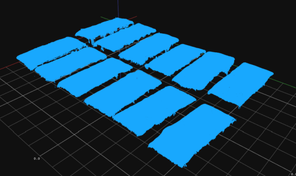
Input Point3DGrid. |
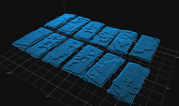
Output Surface. |
ArrangePoint3DGrid performed on a sample point grid.
Errors
This filter can throw an exception to report error. Read how to deal with errors in Error Handling.
List of possible exceptions:
| Error type | Description |
|---|---|
| DomainError | Empty point grid in ArrangePoint3DGrid. |
Complexity Level
This filter is available on Basic Complexity Level.
See Also
- ArrangePoint3DArray – Creates a surface structure from Point3D array taking into account X and Y coordinates.
- CreateSurfaceFromImage – Creates a Surface structure from coordinates encoded in pixels of image.